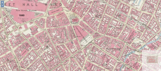
In Search of Old Birmingham - Where was the Market Hall?
Second walk 'In Search of Old Birmingham' with Down To Earth in The City
Heritage Week 2022 - September 13th - Spiceal Street - The Bull Ring - High Street - Dale End
Although the city centre we have in front of us today forms part of an ever-changing landscape with few features of old, we can still navigate the streets (mostly pedestrianised) with some familiarity of the early 19th and 20th Centuries.
 |
| 2022 Looking south from Spiceal Street towards former Jamaica Row (St Martin's on left) |
St Martin's Church, the Mother Church of Birmingham, becomes ever more fascinating the more we delve, the more we look, the more we see. A history dating back to mediaeval Birmingham, overlooking and perhaps overseeing everything and all the changes for many hundreds of years.
From the steps of St Martin's, looking more or less west, our attention eventually turns north up the hill towards High Street. But let's visualise the scene immediately in front for a while. Many of us may remember the 1960s - 2000s setting with the 'new' Bull Ring as was, designed to keep traffic and shoppers apart. By both previous and modern standards the 60s development was gruesome, many would say, a thing of its time, others might argue, but it was short-lived, lasting around 40 years.
 |
| 1970s Bull Ring St Martin's Church out of shot to the left |
From the church corner in the 1970s, one would have seen the ramp leading to the first-floor shopping balcony, maybe Oswald Bailey's outdoor clothing and camping equipment outlet, The Matador pub, although on the photo above it's called The Blarney Stone, a couple of greengrocery stalls and Woolworths (off shot) to the right. Looking north, the imposing St Martins Circus Queensway loomed menacingly above the open market, with buses, lorries and other vehicles tearing overhead, creating a claustrophobic and airless setting.
 |
| 1970s Bull Ring area with the Rotunda (top left of centre) cut off from the market by St Martin's Circus Queensway |
From the Church pre-1960s, it was a very different setting, for one thing, the city was heavily bombed in the 1940s, causing huge irreparable damage, and resulting in a major rebuild which took more than a decade it seems. The Market Hall for one was only demolished in the early 1960s, following severe WWII 1940s bomb damage.


Looks like an interesting look at Birmingham past.
ReplyDelete