The Cattle Run and a view across the City from Highgate Park
A city park, once home to the King Edward VII memorial statue
 |
King Edward VII Memorial at Highgate Park
Photograph by Phyllis Nicklin 1954 of a bronze statue of King Edward VII in Highgate Park. Made in 1913 it formerly stood in Victoria Square and was restored in 2010 and now stands in Centenary Square. See Acknowledgements, Keith Berry |
W👀
Albert Toft was the Sculptor, and he was also the artist for the Boer War memorial at Cannon Hill Park
Memorial sculptures can be controversial as we witnessed in 2020 with the public demolition of the Edward Colston statue in Bristol.
WE CAN'T CHANGE THE PAST BUT WE CAN ASSESS and question HOW WE READ IT AND CHALLENGE HOW IT'S TAUGHT.
William Westley's 18th-century view of Birmingham from the east, the city is surrounded by agricultural land, mostly grazing land, with sheep and cattle raised for the ready, expanding market
 |
Grazing cattle near the 18th-century city centre
(detail of Westley's view)
a similar grazing spot was found on the meadows which we now call Highgate Park |
The former18th-century landscape is today, brimming with concrete and tarmac, and the view, looking west from Highgate Park is one of a CityScape, intriguing nonetheless.
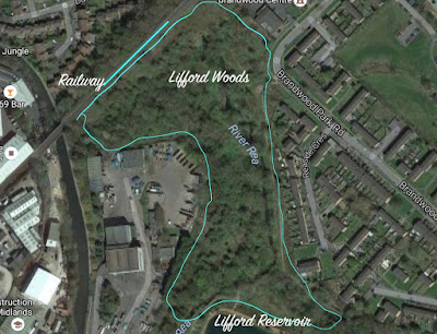
The park is on the slopes of the River Rea, which is mostly subterranean today as it flows through the city.
The river course is just noticeable on the aerial image below, looking closely, it runs more or less parallel to Rea Street, and forms the boundary of Digbeth and Deritend.
 |
| Highgate Park environs
|
In terms of wildlife, one might visualise the wider 18th-century agricultural setting as rich, fertile and fecund, bursting with life in the hedgerows and ditches, woodlands and copses, marshes and floodplains, and so perhaps it was, as wildflower-rich meadow pasture land was buzzing with a myriad of flies, bees, wasps and a multitude of other invertebrate species.
"Birmingham's market is likely to have remained primarily one for agricultural produce throughout the medieval period. The land of the Birmingham Plateau, particularly the unenclosed area of the manor of Birmingham to the west of the town, was more suited to pastoral than arable agriculture and excavated animal bones indicate that cattle were the dominant livestock, with some sheep but very few pigs." (Wiki)
- Buteux, Simon (2003), Beneath the Bull Ring: The Archaeology of Life and Death in Early Birmingham, Brewin Books, ISBN 978-1-85858-242-9
But this was changing as the competition for animal pasture and urban development was taking place throughout the region.
There are accounts describing the herding and droving of cattle along Bradford Street to the abattoir and meat markets near the city centre, reminiscent of the wild west.
Drover's roads were ancient farm animal movement routes between pasture and marketplace, and Wales to Birmingham 'drove', enabled the movement of cattle before the railways took precedence. The Chester Road was a major route between North Wales and Birmingham.
During the 19th Century, we might imagine that cattle, imported from out of town, were transported via Bordesley Cattle Station, corralled at the railway sidings at Highgate, before herding along Bradford Street and on to the abattoir at Moat Row. An awesome sight, if not brutal in its operation, animal welfare, perhaps not top of the agenda.
 |
Bordesley Station
|
"In 1817 the Street Commissioners opened the Smithfield market on the site of the Birmingham Manor House, new wholesale fruit and vegetable markets opened on Moat Row in 1883, and the pig and cattle trades moved to a new market in Montague Street between 1892 and 1898. The wholesale fish market in Bell Street was opened in 1869 and extended in 1883, while in 1897 a new meat market with an attached slaughterhouse was opened in Bradford Street." https://birminghamwholesalemarket.company/about-us/history/
 |
The Drovers' Arms, Bradford Street/Moat Row, Deritend, BirminghamNicklin, Phyllis (1968) The Drovers' Arms, Bradford Street/Moat Row, Deritend, Birmingham. [Image] (Unpublished) Photograph of the Drovers' Arms at the corner between Bradford Street, and Moat Row. On the right, the meat market and abattoir, built-in c. 1895-7. The photograph, showing a late 18th-century suburb, begun in c. 1767, was taken in late 1968. Gates to the Cattle Market on Bradford Street
Drovers Arms to the left and the meat market and abattoir in the distance.
|
Bradford Street - from Highgate to City Centre
Top; looking towards Highgate
Bottom; looking towards the city centre
A cattle run from railway to market
 |
Cattle pens next to the railway sidings near the Friend's Institute and Highgate Park (1890)
From Birmingham History Forum "I lived in Showell Green Lane from 1940 until 1961. I remember seeing sheep & cattle being driven along Stratford Road, must have been in the forties, probably from Hall Green Station to the abattoir in Bradford Street." "1897 St Martin's Meat Market moved to new premises (with an abattoir) in the area bounded by Bradford Street, Sherlock Street and Cheapside and re-named the City Meat Market"
|
 |
A southern prospect of Birmingham from Highgate Park
The site, once a sheep and cattle fold, went on to become Birmingham's first municipal park
The park was officially opened on 2nd June 1876, by the Mayor Joseph Chamberlain
Today, we wonder about its values once again. |


Comments
Post a Comment